My teenagers and I set out to hike Cannon Mountain in Franconia Notch a few weeks ago. Our goal was to stop for lunch at the Lonesome Lake AMC Hut and continue to the summit. However, things didn't work out quite as planned.
Here are 9 things I learned (or more accurately, re-learned) on this hike.
1. Hiking with kids is not always predictable – particularly in the supplies needed-department – even when they are teenagers.
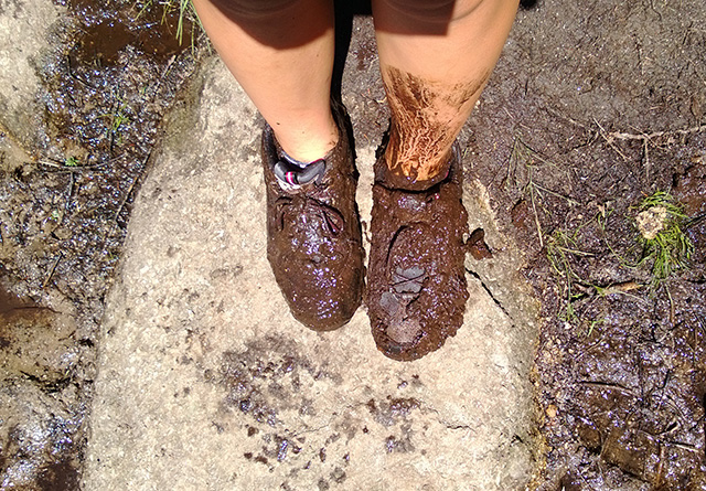
2. Teenagers might fall in mud accidentally but it is just as messy as when they were preschoolers. Only this time mom doesn't have that change of clothes (or socks) she always used to carry for her babies.
3. The Lonesome Lake Hut sell socks!
4. The hut only takes cash (which is, of course, obvious). Thankfully I had exactly the right amount of cash (down to the last four quarters - and why we had (heavy) quarters instead of (light) bills is still a mystery) to buy a pair of clean socks AND the coveted Lonesome Lake Hut patch the girls wanted for their backpacks.
5. Muddy hiking boots – then dipped in a lake to wash off (with feet still in them, which mom did not recommend but was done anyhow) – do not dry in the sun in an hour.
6. Hiking up the trail in squishy, soaking wet hiking boots is not a good time for a hiker.
7. Changing plans and turning around to head home after lunch rather than visit the summit is a good choice for everyone in the hiking party.
8. Each hiker should be responsible to pack a clean pair of socks in their backpack.
9. Everyone should bring their sense of humor to the mountain. I can't remember a time I didn't need to pull that particular item out of the pack at least once during a hike!
Exhibit 1: Hiker's self-portrait of muddy faux pas. ...and solution to the problem.
Exhibit 2: Younger sibling trying to contain laughter for having navigated the mud with less mess (and replay the video she took that mom is not allowed to share here of her sibling screaming about falling in the mud).
Exhibit 3: New ($13) socks from the AMC hut.
Exhibit 4: An hour in the sun (without feet in them) does not dry soaked hiking boots but you still need to put them back on anyway. A silly swimmer can make the hiking party smile and therefore all seems OK again.
ON ANOTHER NOTE....
It is possible to be photo bombed by a dragonfly, just in case you were wondering.
Mount Zircon in Rumford offers a wonderful mountain-top view of the area. What it doesn't offer is the best signage.
The kids and I have spent a lot of time this summer in the White
Mountains National Forest (both in Maine and New Hampshire) and have
come to expect certain signage, thanks to our familiarity with the
national forest. It's not that Mount Zircon's trailhead isn't marked,
because it is. It is just not obvious -- and not in the place you might
expect.
The old dirt road that serves as the initial start to the
trail looks like someone's driveway, complete with house, camper and
backyard pool. And once on the trail, the sign turning off the main
trail to the summit of the mountain is set back.
On this trail, put your eagle-eyed kids to work looking for the key signage.
While
driving, I realized we had passed the trailhead and found a place to
turn around. My kids were delighted to find a handwritten sign at the
spot I turned around that said, "For Mount Zircon Trail take the road
after the bridge." We turned around and found the Tree Farm sign for the
Rumford Water District that included a smaller sign just above it for
Mount Zircon.
We parked on the small grassy shoulder at the
trailhead and passed that house (and pool) as well as a locked red gate
to walk up the gravel road that starts the trail. It was a steady but
not overly steep climb. About a mile and a half up the old road, we
found the remains of the old Zircon Water Bottling Company. The Maine
Mountain Guide description we read indicated there was a pipe with
running water from the spring. The water looked clean flowing out but
the pipe itself seemed slimy and not so clean. In a pinch I would have
drank the water but we had plenty in our pack so we took a pass. Still
an interesting stop, though.
We hiked up the trail and after a
while felt like we'd missed our left-handed turn up to the summit. My
mapping program that tracks our progress on the trail indicated we were
likely too far into the road and had missed the turn. After a second
pass in the area we still didn't see a sign on the trail. A third return
pass (there is apparently a reason for the cliche "third time's the
charm") was when we finally spotted the white, round "Mount Zircon"
trail sign on a tree. It was set back about 50 feet from the trail amid
an overgrown area of ferns and greenery. It is a pretty obvious sign
once we knew where to look. But when you're used to signage being on a
tree or post on the trail itself, we simply weren't looking in the
correct place. With all the passing by, we'd hiked about a mile more
than we needed to before the real climb to the summit actually began.
Yeah, call us knuckleheads if you will but only after you visit this
trail in the height of summer's foliage. If you have a GPS application
on your phone, input these GPS coordinates (44.4791, -70.5669) before
you leave to ensure you don't miss this trail sign.
The summit
trail is a narrow path through a more dense forest. Closer to the summit
the trail got rocky and the footing a bit trickier because the rocks
were slippery with recent rain. It wasn't especially difficult but it
did require more purposeful stepping.
We reached the summit to
see a fallen-down fire tower and a wonderful mountain-top view. The fire
tower carnage was interesting but the kids and I found the wind
turbines on Spruce Mountain to be another fascinating feature. We also
spotted some of the mountains we've hiked previously and that's always a
fun geography lesson for the kids.
The mountain summit at 2,240
feet (with an elevation gain of about 1,600 feet), makes this a
"moderately difficult" hike, according to the Maine Mountain Guide. I'd
say it's "difficult" for a family of occasional hikers. But if you have
kids who like to hike and you've climbed some other mountains this
season, you'll enjoy this trek. The climb is worth the effort for the
wonderful views.
MOUNT ZIRCON, RUMFORD • Trail head GPS coordinates: 44.5057, -70.564 • Trail length: about 5.4 miles round trip • Elevation gain: about 1,600 feet • From the junction of Routes 26 and 232 in
Woodstock, take Route 232 for 6.8 miles to Abbotts Mill. Turn right on
S. Rumford Road and drive about 6 miles to a gated gravel road on the
right. There is a Tree Farm, Rumford Water District sign with a small
Mount Zircon sign above it.
We have spent a lot of time in Evans Notch this spring and summer. Actually we have spent a lot of time in this area over the years. It's about 20 miles north of Fryeburg and has some amazing mountain views.
But in addition to finding some wonderful summits, we've also found a gem of a place to stop to get snacks before we set out on the trail – Quinn's Jockey Cap Country Store (at 116 Bridgton Road on Route 302 in Fryeburg). On first glance it looks like a typical locally-owned convenience store set in any small town in Maine. But this place has bakery-quality desserts and lots of homemade goodness. We've had delicious cakes, cookies, cheesecake and other treats from this place. They also have all sorts of sandwiches and pizza (for breakfast and lunch) and plenty of the typical hiking fare of granola bars, nuts, chips and water. It's a well-stocked place. One thing about it though, it's not particularly inexpensive. But as far as bakery treats and lunch sandwiches go, it's a tasty stop.
The girls and I are not big potato chip eaters but when we pick up a bag, it's typically a salt and vinegar type flavor. At the Jockey Cap Country Store recently we saw several different types of Utz chips and decided it would be fun to buy a variety for a taste test at the summit of Blueberry Mountain (our hike du jour). We also decided to pick up a couple of danishes – raspberry and apple – to round out the sweet versus salty snack experience on the mountain top.
Blueberry Mountain is not the toughest climb we've ever done but in the summer heat, it is a sweaty workout. But it wasn't so bad on this recent trek because we knew we had some fun taste-testing planned once we got to the summit.
The Kettle Classic "Salt and Malt Vinegar" Utz chips won hands-down (or thumbs up if you roll that way) in our book for the tang of the malt vinegar.
We also found some natural goodness to snack on near the summit as well.
Hiking up a mountain can be a serious workout challenge but when you pack the right kind of motivational snacks and approach the day with fun and silliness, everyone in the family has a good time.
It's not always about the view on every trip for us... although we have found that a beautiful setting sure does make everything taste better.