Sunday, December 7, 2003

Kid Tracks Column: Mount Agamenticus great for families

It was a clear but brisk windy day when we went for our mid-November hike on Mount Agamenticus in York. We chose to hit the trail on a Sunday to avoid hunters. But just in case, we still wore our bright orange knit hats.

We started our hike at the top of the mountain because the parking lot at the base trail head was full. The top of the mountain offers a lot more parking and we had no trouble finding a spot there.
The series of trails at Mount Agamenticus are great for families. There are trails as short as a tenth of a mile, with the longest trail measuring 1.5 miles. Hikers can also combine several trails easily because they are well-marked. There are trail maps available at several trail heads around the mountain or you can print out a trail map online at www.mtanemba.org/maps.html.


The trails at Mount Agamenticus are part of a network maintained by a conservation coordinator and crew as well as volunteers. Several trails are open not only to hikers but also mountain bikers and horses. There is a horse stable at the top of Mount Agamenticus run by the York Parks Department but it was closed last season due to budget issues.

The day we went on our hike there were a lot of families with young children as well as several mountain bikers, despite the cold temperatures.

For us this hike was especially fun because the kids had such a great time playing goofy games along the trail. As a parent I'm always encouraged by my children's ability to make the simplest things, such as piles of leaves and patches of ice, so entertaining.

We dressed more warmly than we have during other hikes because the temperature was barely 30 degrees and, with a strong wind, we assumed we'd be mighty chilly at the top of the mountain (but it was still a surprise to see the ice patches, our first sighting of the season). To avoid any complaining on the hike I encouraged my daughters, ages 6 and 7, to wear lots of layers. They wore cotton tights under their jeans with a T-shirt, turtleneck, sweatshirt and their winter jacket on this trip. They each had a set of mittens, a scarf and their orange knit hats. Now you might think I'm a bit over-the-top with the layers, but if my kids are uncomfortable (hot or cold) they whine. By wearing multiple layers they can peel off a layer if they get hot.

So what should you do to get your family ready for hiking during the colder months? Here are a few ideas:


  • Wear layers both on the upper and lower body. Cotton tights or long underwear under jeans keep legs warm when snow pants aren't worn.
  • Make sure the kids take off their coats in the car. If the kids have several layers on under their coat and the trail is 45 minutes away, that makes for a long, hot ride. Also, sweating indoors and then going outside can cause chills because the layer closest to your body is already damp.
  • Pack an extra pair of mittens or gloves in your backpack for each family member. My children inevitably find a way to get their mittens wet. Or they may take a mitten off to pick up something and then somehow the magic fairies have flown off with it, never to be seen again.
  • Pack snacks and drinks that are easy to open (and eat) with gloves on. Packing applesauce or yogurt (my 6-year-old's favorite snack) is fine in the warmer months but a little too time-consuming, messy and hard to eat in the cold.
  • Pack plenty of tissues - and keep them handy. It seems everyone's nose starts running when the temperature drops. And I'd bet most parents are like me and prefer their children use a tissue rather than their mitten or coat sleeve.
    We realized on this hike that we needed to "re-season" our hiking backpacks. I periodically check to make sure we have plenty of adhesive bandages, gum (a family remedy for calming the crying that goes on with minor injuries), and other items we use on the trail (for more information about our first aid kit, see my previous column East Point Sanctuary)

    With this hike I was so concerned about making sure we were all dressed for the cold weather, I never checked the backpack's supplies. We ended up carrying items we simply had no need for in cold weather - like bug spray. And until the snow starts flying, we really didn't need the bottle of sunblock we had either. So it's best to go through your backpack during each change of season.

    We spent about an hour and a half on the trail. You don't have to be a hard-core outdoors-type family to venture on a hike during the colder months. With a little extra planning your family can spend some time together and find your own fun on the trail, even if your outdoor adventure is a little shorter in the cold weather.

    Trail name: Mount Agamenticus
    Nearest town: York
    Region: Southern Coast
    Length: There are multiple trails ranging from 0.1 to 1.5 miles.
    Difficulty: Easy to Moderate depending on trail
    Elevation: 692 feet
    Other: The trail is wooded. The top is an open, grassy area. There is a small parking area at the base trail for about a dozen cars. The top of the mountain offers a larger parking area. The lodge at the top of the mountain is a function hall and not open to the public. There are no mountain bike rentals on the mountain but there are several trails open to mountain bikers. The trails are open during the winter months but are not groomed.
    Hazards: We encountered several large ice patches during our mid-November hike.
    Directions: From Route 1 in York, turn onto Mountain Road. At the stop sign on Mountain Road turn right. The base of the mountain is 2.7 miles.


  • KIDS' REVIEW
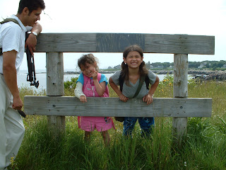
    Even though we chose to hike on a Sunday, a no-hunting day, we decided to wear bright orange hats as an added safety measure while on the wooded trails. Click here to see a slide show of photos.
    (12 images) AudioListen to the 7-year old describe her experience on this trail...
    (50 seconds, 500k mp3 format)

    AudioListen to the 6-year old describe her experience on this trail...
    (16 seconds, 168k mp3 format)

     
    Originally published by the Maine Sunday Telegram December 7, 2003

    Sunday, November 2, 2003

    Kid Tracks Column: Finding Jockey Cap worth effort

    Taking a hike to see the colorful fall foliage was our plan for this month's hike. But the days open in our schedule turned out to have less than cooperative weather.

    So we found ourselves watching the weather reports last weekend and with another rainy weekend approaching, decided to take a short Friday afternoon hike before the bad weather moved in.

    It was a brisk but mostly clear afternoon as we set out for Jockey Cap in Fryeburg. Several friends had recommended this hike and all had said the trailhead was easy to find. So we left the house without any specific directions except that the trailhead was right next to a country store on Route 302.

    Now, of course, anywhere is "easy to find" when you've been there or are familiar with a particular area. I think understanding directions is an art. I have always found Maine a friendly, helpful place and the locals have pointed me in the right direction whenever I've needed help. But I've had to learn how to translate the information into something I can actually use to navigate.

    When someone says, "Oh, the trail is just a mile down the road," I have to think about whether that's enough information to get me there. And to wonder if my odometer's mile is the same as my direction-giver's mile.

    One of the most important things I've found in asking for directions is to ask for landmarks. For instance, which side of the road is the landmark on? If I've gone past it, what will I see? About how far from this landmark is the trailhead?

    Landmarks can be highway intersections, a country store — as was the case with Jockey Cap, or a sign by the road.

    We have found in our hiking experiences in Maine that not all trailheads are marked with signs, some simply have tree line markers (as was the case on our Brownfield hike last month) and it takes some eagle-eye lookouts, namely our kids, to find the stop.

    And I have to take a moment to say that kids can be helpful lookouts and at the same time blood-pressure raisers. There's nothing like a peanut gallery in the back seat asking you if we're lost and if we're ever going to get there. Or even better, "Mommy (or Daddy), you should have gone the other way instead." Ah, the joys of those early-blooming backseat drivers . . .

    So in addition to vague directions, I don't remember our friends telling us how unusual the Jockey Cap trailhead was. Now those of you who have been to Jockey Cap will say how could you think it's hard to find? Well, we didn't expect that the trailhead (which is set back from the road) would look like it was on private property. It just didn't feel right somehow.

    So we passed the country store and went a little further down Route 302 before stopping and asking at a local business where the trail was.

    A very friendly man explained where the trailhead was and I realized we had already been there. It turned out that it was clearly marked by a large sign that says "Jockey Cap Trail," once we knew to look between the Jockey Cap Country Store and the Jockey Cap Motel.

    So after feeling really stupid, we parked our car in front of the motel and set out on the trail.

    Early on the trail, there were some rocks that formed a small cave and the kids loved crawling in and around this area. They thought it was a "cool playground" and spent a long time exploring the cave and rocks before they would agree to continue on the trail. At that point we could see the face of Jockey Cap (and we saw mountain climbers scaling it on our way back down the trail).

    There were lots of fallen leaves covering the trail, but the path to the top of the mountain was pretty clear. The ascent is steady, but with only a 200-foot elevation gain and only 0.25 miles of trail, it's easy to navigate.

    Once we arrived at the top, which offers a beautiful 360-degree view, we found a round stand with a mold of the surrounding mountains and lake. The kids were fascinated with the map and had fun matching up the mountains with the molded peaks. We had to pick up our 5-year-old so she could see at the correct angle to match them up. The mold is a nice height for adults but a little tall for younger kids.

    The fall colors were in full bloom the afternoon we spent there. It was a breathtaking view. The kids found a spot to sit on the rocks and watched a middle school soccer game on one of the fields below us. They also saw what looked like a Fryeburg Academy football scrimmage a little further in the distance.

    The kids thought it was really cool to view the games from the mountain's height and that made the weekday hike even more enjoyable.

    If you're taking young children, be sure to stay close to them at the top — there are a few places where there are steep drops. There are, however, lots of places to explore along the wooded trail at the lower elevation, so that children can run ahead and climb over the smaller rocks by the cave without much worry.

    We spent about 1.5 hours on the trail with quite a bit of time spent watching the sporting events. If you're looking for a hike but don't have a lot of time, or don't want to spend too much time outside as the weather grows colder, this is the trail for you.

    Trail name: Jockey Cap
    Nearest town: Fryeburg
    Region: Western Mountains
    Length: 0.25 miles
    Difficulty: Easy
    Elevation gain: 200 feet
    Other: There is a small parking area in front of the motel.
    Hazards:The top isn't huge and there are some steep drops so parents should stay close to young children to be sure they don't go too close to the edge. Directions: From the intersection of Routes 113 and 302 the trailhead is exactly 1.0 miles. The trailhead is between the Jockey Cap Country Store and the Jockey Cap Motel.

    AudioListen to the 7-year old describe her experience on this trail...
    (53 seconds, 524k mp3 format)
    AudioListen to the 5-year old describe her experience on this trail...
    (25 seconds, 440k mp3 format)


    Originally published in the Maine Sunday Telegram November 2, 2003 

    Sunday, October 5, 2003

    Kid Tracks Column: Reconnecting on Brownfield trail

    Finding time to hit the trail with the kids now that school, soccer, dance classes and everything else that their fall schedules include was a challenge. But hiking is something we all love to do, so we made the time.

    We chose what turned out to be the most challenging hike we've done this year with the kids in the Burnt Meadow Mountains in Brownfield. The terrain is rocky and fairly steep, but the feeling of accomplishment in making it halfway up the trail was gratifying. The kids, and their parents, got quite a workout on this hike.

    We had a little bit of trouble finding the trail head because there are no signs marking ithe trail. We clocked the mileage from the intersection of Main Street and Route 160 in Brownfield to the trail head at. It's 2.9 miles. The trail head can be identified by a cleared-out dirt area for about five or six cars. I couldn't confirm the name of the trail with the town of Brownfield, but it is often referred to as the Burnt Meadow Mountains trail by local hikers.

    The tricky thing about this particular trail head is knowing where to start. There are two paths leading from the parking area. We initially started out on the path in the center of the parked cars and realized quickly that it wasn't correct because there were no trail markers. We backtracked and noticed that the tree to the far right of the parking area was marked with blue lines.

    Once we embarked on the marked trail we followed a steady ascent. It's not steep as much as steady. There are places along this trail where the kids required some assistance in scaling some tricky rocks. They thought it was great to be hiking another "real mountain" (they loved Douglas Mountain earlier in the season). They soon realized that this trail was much longer than Douglas Mountain and started to get tired after a mile or so. There was a nice clearing with a beautiful view, so we stopped for a water break and decided to linger for a while.

    In an attempt to keep things interesting for the kids, we brought along paper and crayons. I suggested they take a break and color something they saw on the trail. It was a picture-perfect 70-degree, sunny September day and soaking in the warm sun on a peaceful mountaintop was just what we all needed. We talked and colored and simply enjoyed being together, which we hadn't done much of since school started.

    Jeri Schroeder, a co-facilitator for the "Shapedown" program at the University of Southern Maine, has found during her work that the lack of family connections with kids on tight schedules, and both parents working, can in some cases lead to childhood obesity. During her work with the family-based education intervention program for overweight children, she helps children — and their parents — develop ways to find comfort in their family connections rather than in food. My husband and I know from personal experience that our kids can't wait for the next hike because they know they get our full attention out on the trail.

    Schroeder has also found during the course of her work and in her own personal experience with her grown son, that parents who exercise and participate in physical fitness activities give children a model to follow.

    "Children learn from what parents do and pick up behaviors that are modeled for them. When both parents are involved in physical activities, kids learn to do that too," says Schroeder.

    So if you haven't taken your children out hiking yet because you haven't been able to find the time, you have even more reasons to get hit the trail now.

    After our leisurely break on the rocks we decided to start moving again. We hiked a little farther down the trail, but the kids were tired and started tripping on the rocks. We decided they'd made quite an accomplishment getting as far as they did so we turned around and headed back. When we take the kids out on a hike, especially one we've never done ourselves, we try to stay flexible. We praised them for the distance they did and decided hiking over a mile back down the mountain was going to be enough of a challenge for them.

    It turned out that the descent was in fact trickier for the kids than we had thought. We decided the best way to get down the steep rocks was to use the "Almeida skooch" method. The kids sat on their bottoms and crab-walked using their hands and feet down the steep rocks, with my husband in front and me in the back. It took us longer to get down the trail than up, but the kids love to "skooch" so it became a game.

    We spent about two and half hours on the trail. If your family has some experience hiking and is looking for a challenge, I recommend this trail. I wouldn't, however, recommend it for children under age 5 unless they are more athletically inclined or have some hiking experience.

    This early fall hike was a great way for our family to reconnect after a busy couple of weeks. And as most parents know, there's nothing more gratifying than pulling into your driveway with two sleeping cherubs in the back seat who have just spent a wonderful afternoon outdoors.

    Trail name: The name of the trail couldn't be confirmed by the town of Brownfield but is generally referred to as the Burnt Meadow Mountain trail by local hikers.
    Nearest town: Brownfield
    Region: Western Mountains
    Length: Several miles.
    Difficulty: Moderate for adults and older children, difficult for younger children. I would not recommend it for children under 5.

    Other: There is a small parking area at the trail head for 5-6 cars.
    Hazards: This is a steep trail for young children and finding footholds during the descent is challenging for young children. Directions: From Route 113 west turn left onto Main Street in Brownfield (just before the gas station) and stay on Route 160 south. The trail head is 2.9 miles down Route 160. There are no signs marking the trailhead but it looks like a turn-out off the shoulder. You will see a tree with a blue marker to indicate the start of the trail.

    AudioListen to the 7-year old describe her experience on this trail...
    (50 seconds, 988k mp3 format)
    AudioListen to the 5-year old describe her experience on this trail...
    (22 seconds, 440k mp3 format)
     

    Originally published in the Maine Sunday Telegram October 5, 2003

    Sunday, September 7, 2003

    Kid Tracks Column: Wolfe's Neck amble offers myriad lessons

    Wolfe's Neck Woods State Park offers some great trails for families. There are short, easy paths that interconnect, giving visitors choices on the length and type of trail they want to follow. Some terrain offers smooth surface dirt while others are rougher for more of a challenge.

    My friend recently visited the park and he and his young nephew were stung by a bee there. Neither had a bad reaction to the stings but he was surprised to find that his store-bought first-aid kit did not have anything specifically to treat the injury.

    After looking at my family's first-aid kit, I realized that I had some antihistamine for adults but not for kids. So on the way to our hike we stopped off at our local supermarket to pick up something for them in case we ran into some bees.

    I asked Roy St. Clair, a pharmacist at Hannaford in Colonial Marketplace in Standish, what he thought was the best way to treat a bee sting in a young child. He said the remedy he recommends is a paste of meat tenderizer and water. He said to mix the powdered meat tenderizer with some water until it turns into a paste. Then apply the paste directly to the affected area.

    He acknowledged my look of surprise but said a pediatrician recommended the remedy to him 50 years ago, with great results. And an assistant in the pharmacy, Louise Lieberum, said her 4-year old son was stung by a bee recently and the remedy, "worked great."

    So I left the pharmacy and headed for the baking aisle. Once I purchased the meat tenderizer (seasoned or unseasoned, it doesn't seem to matter) we were off to the park.

    Finding our way to the park from downtown Freeport was easy. We took Bow Street from downtown Freeport and about two to three miles down the road we spotted signs directing us to the park's main entrance.

    We paid our admission fee ($3 for adults, $1 for kids ages 5 to 11) and were given a pamphlet explaining the rules of the park and detailed information about several of the trails and their mileage.
    Our family decided that we would try to hike two miles since the longest hike we'd taken this season was one and a half miles. In order to work that mileage into our hike we had to combine trails. We chose to hike parts of the White Pines, Casco Bay, Harraseeket and Ledge trails. It was close enough to two miles for us to be satisfied with the challenge.

    The first thing the kids noticed as we started along the trail was the smell of the ocean. They were ready to make a break for it until they realized the terrain on this ocean trail was different from our last hike at Biddeford Pool. There are small paths and/or steps leading down to the rocky shore from the Casco Bay Trail. This trail is like a ledge that runs parallel to the ocean. Parents need to be cautious about letting their kids run ahead because the path leading down to the water is steep in some places.

    Once down on the rocks, we had a wonderful view of Casco Bay and the Googins Island Osprey Sanctuary. We saw several birds flying above the island and the kids wanted to get a closer look through the binoculars. My 7-year-old is adept at using the binoculars but my 5-year-old needed some help focusing them. The binoculars and bird-watching kept the kids busy for quite some time.

    There were several "interpretive panels" along the Casco Bay Trail as well as some of the other trails. Each time we came upon one of these panels, the kids would run to it and yell "map, map!" (I believe they were re-enacting their favorite TV show featuring the little Spanish-speaking girl who also loves maps.) In viewing the illustrations and reading the information on the panels, we were able to educate ourselves — and, in turn, the kids — about the area. It's a nice feature.

    We visited the park on a weekday and on the main trail we saw lots of visitors also enjoying the park. There were all kinds of hikers, from very small children to elderly couples to people walking with their dogs. Once we moved off the Casco Bay Trail, we saw fewer people and the terrain became a bit more challenging for the kids.

    Because the month of August was so wet, some of the trails deeper in the woods were a little muddy and slippery. The Ledge Trail had lots of exposed tree roots and uneven terrain which made my accident-prone 5-year-old more cautious. But she managed without too much difficulty.

    Another byproduct of all the rain was the variety of mushrooms we saw. There were various shades of purple, red and brown mushrooms. We told the girls not to touch them because they might be poisonous. After speaking with a park ranger, who was wonderfully helpful and enthusiastic about answering our questions, we learned that if you touch a poisonous mushroom you might not get sick. But if you don't wash your hands and have a snack or touch your mouth with your hands, the spores from the mushrooms can enter your mouth. And that is what will make you sick. So the best policy to teach kids is NOT TO TOUCH the mushrooms.

    The trails at the park aren't that difficult to follow and most are marked. But when you move in and out of different trails, it's possible to get confused until the next trail crossing. At some point we weren't quite sure which trail we were on so I stopped to look more closely at the map. My 7-year-old was appalled to think that we were lost and suggested we "just use our compass." My husband thought it a great opportunity to teach her how to orientate the compass with the map. As we were showing the girls what to do, an older couple stopped to ask us if we knew which way to get back to the parking lot. My 7-year old pointed down the appropriate trail and suggested they follow it until it ended. She was right — and quite proud to have figured it out.

    We hiked about two miles in approximately three hours, with leisurely stops to view the birds, wildlife and mushrooms and to have a picnic. This hike offered a nice variety of terrain and sights. And luckily, none of us got stung by a bee (although we did see a few). But boy, I sure am glad I packed some meat tenderizer just in case!


    Trail name:Wolfe's Neck Woods State Park
    Nearest town: Freeport
    Region: Greater Portland
    Length: There are 8 trails totaling approximately 5 miles.
    Difficulty: Easy to Moderate, depending which trail you choose.
    Elevation gain: at sea level
    Other: The "interpretive panels" along several of the trails offer helpful and interesting information and illustrations about the area.
    Hazards: Being a trail near the coast hikers should be aware of poison ivy  
    Directions: Take Bow Street from Main Street in Freeport. About 2-3 miles down Bow Street there are signs directing visitors to the park. 

    KIDS' REVIEW
    The author's 7-year old viewed the birds flying over the Googins Island Osprey Sanctuary with binoculars. The island is close enough to the shore that binoculars aren't necessary but provided a great opportunity to teach the kids how to use them. Click here to see a slide show of photos.
    (12 images) AudioListen to the 7-year old describe her experience on this trail...
    (30 seconds, 160k mp3 format)


    Originally published in the Maine Sunday Telegram September 7, 2003

    Sunday, August 3, 2003

    Kid Tracks Column: It's a breeze: Hiking a trail by the sea

    Looking for some variety during our summer hikes, my children decided we should find a trail near the ocean. After consulting a few sources we decided on the East Point Sanctuary in Biddeford Pool.
    It was a warm summer day and getting wet was something the kids were definitely planning to do.

    The trail starts off with lots of trees and bushes and then leads along an open, grassy area that borders on a golf course. It didn't take long to catch a glimpse of the ocean and the kids took off running towards it.

    Usually we make the kids wear sneakers on our hikes. We assumed that they would be getting wet  – that was their point in choosing this hike — so we allowed them to wear their sturdy, thick-soled sandals. It was a good choice. As soon as they could reach the ocean, they were in it, sandals and all.

    There were some wet, slippery rocks in the water so my husband and I stayed close to them while they were climbing. We wanted to avert any big falls. Despite our best efforts and reminders my 7-year old ended up slipping on some rocks while she was supposedly walking (running as fast as she could would be more accurate) in the water. It wasn't a serious fall but required some antibiotic cream, a band-aid and our family's magic remedy -- gum. The gum seems to have a magical power over my kids' injuries. They don't feel the need to cry as much as they do to chew.

    Making sure you have a useful first aid kit is very important when out on the trail with kids. Here's a few of the items we carry in our packs during a day hike:


  • band-aids
  • antibiotic cream
  • alcohol swabs
  • moleskin
  • ace bandage
  • waterproof tape
  • anti-itch lotion
  • scissors
  • tweezers
  • gum  


  • We also carry our bug spray and sun block in the first aid kit because we use those items a lot. By going in and out of the kit we are more apt to notice what we need to replenish. There's nothing worse than thinking you have something in your bag and then realizing you used it all on your last outing.

    According to Peter Wilson, the Property Management Assistant for the Maine Audubon Society, poison ivy is often found on shoreline trails in Maine. The East Point Sanctuary is no exception. He encourages hikers to stay on the marked trails to avoid coming in contact with the plant. Parents should make sure they know what poison ivy looks like so you can avoid it. While we were out on our hike we stayed on the marked trails and did not encounter any poison ivy.

    Discovering snails was one of the highlights of this hike for the kids. There were also several types of seaweed that the kids loved to touch because it was "slimy." We also found tons of seashells and interesting rocks.

    The Wood Island Lighthouse was visible from the trail and I was directed by both kids to take photos of it. They waved to a group of sea kayakers making their way along the shore and all the sailboats that likely couldn't see them. They didn't seem to mind.

    After a leisurely picnic we continued along the trail at the shore. The rocks got to be more challenging than we thought our kids could handle. We opted to climb up onto the grassy part and make our way back to the trail head along the dirt trail. Older children looking for a challenge could likely have hiked further down the rocky coastal trail. There are several outlets from the rocks that lead back up to the main trail. Navigating the coastal trail is fairly easy.

    We spent about two and half hours on the trail. Most of that time was spent climbing rocks around the shore.

    Our hike along this ocean trail on a hot summer day kept us all cool and comfortable, which always makes being together on the trail much more fun.

    Trail name: East Point Sanctuary
    Nearest town: Biddeford Pool
    Region: Southern Coast
    Length: 1.8 miles
    Difficulty: Easy to Moderate. The trail to the shore is easy but once at the shore, there are large rocks to climb through if you want to continue along the coast.
    Elevation gain: at sea level
    Other:There was on-street parking Lester B. Orcutt Boulevard for about 12 cars. Parking is limited.
    Hazards: There is poison ivy along the trail as well as brown tail moth caterpillars. Directions:Take Route 208 toward Biddeford Pool. After 0.6 miles, turn left at the T intersection, then bear right through two forks to Lester B. Orcutt Boulevard, following it to the point. The gate entrance is on the left side.


    Originally published in the Maine Sunday Telegram Aug. 3, 2003

    Sunday, June 8, 2003

    Kid Tracks Column: A trip up Douglas Mountain offers great views

    Getting the family excited about hitting the trail takes some planning and a lot of flexibility. Giving everyone a chance to make choices about the days' activities, even with young children, can make all the difference.

    I have two daughters, 5 and 7 years old, and they love to be outside. We took them to California two years ago and did the Disneyland thing but it was our 4-day camping trip on the Central Coast in California that they remembered most and talked about when we returned to Maine. So we decided from that point on, going on a trip really meant doing something outdoors.

    In planning for our first hiking trip of the season, my husband and I picked a couple of short day hikes and presented them to the kids. Because of their ages, we kept the explanation of options simple by asking them if they wanted to see the ocean or the mountains. They were thrilled to make the final decision for us and decided on Douglas Mountain.

    The night before the hike we each packed our own backpack. My 7-year old packed a bottle of water, a granola bar, a jacket, a jump rope, a stuff animal and a notebook with pencil. I asked her if she really needed a jump rope and she said, "Mommy when we get to the top of the mountain I think I might want to jump rope." I tried to explain that she might want to rest at the top of the mountain but she insisted. As most parents know, choosing your battles is important and since a jump rope wasn't going to add any weight to her pack, I said nothing more.

    My 5-year old decided she was going to hike up the mountain with a wicker basket. She decided she would be like Little Red Riding Hood and didn't need a pack. I almost went along with that one since she couldn't carry much in that basket, but then she seemed to figure that out too and decided on the backpack. She packed a bottle of water (at least both girls were practical), 2 single-serving containers of applesauce, a metal spoon from our silverware draw, a mini robot bunny and a little plastic bed for the bunny. "Bunny has to climb the mountain mommy. He'll be so sad if he can't see it." she told me. Ok, so here's another example of choosing battles so the bunny, and her bed, went with us. I did draw the line however at the silverware and replaced that with some plastic fare.

    My husband and I packed a first aid kit, a picnic blanket, extra water and snacks, binoculars and a camera.

    We were lucky enough to hike on a picture-perfect day in May when the visibility was near 100% at the top of the mountain.

    The guidebook we had suggested starting at the top of the trail on Dyke Mountain Road. But after speaking with a few friends, we decided to start at the bottom of the "Woods Trail," which is at the end of Douglas Mountain Road. We thought we should start the toughest part of the hike first (meaning the ascent).

    At the entrance of Woods Trail, which is managed by the town of Sebago, there's only enough parking for maybe 6-8 cars which wasn't a problem during our visit because there weren't many hikers on the trail that day. If you're going to hit this trail at the height of the season, you should leave early to assure a place to park in this area. The entrance to another trail off Dyke Mountain Road offers a larger parking lot for a fee.

    Along the trail, which is marked, we saw lots of quartz deposits and the kids marveled at it for quite some time. It also kept them moving up the trail to see more of it and in turn, got us to the top without any complaining about the steep climb. Another motivating factor to continue down the path was the stone lookout tower, which my 7 year old knew about from a hike she took with her summer camp last year.

    Even with the steepness of the trail, it only took about 15 minutes to get to the tower. While we were on the trail we saw a hiker with a dog (leased animals are welcomed on the trail), a couple of adults with a toddler and a baby and another family with elementary-aged children. The trail is very do-able for a variety of abilities and ages.

    When we got to the lookout tower the kids ran right up the stone steps to the top. We had a great view of Mount Washington and the mountains on one side and Sebago Lake and the other region's lakes on the other side.

    The whole trip, including a leisurely picnic at the top, took us two hours. It was a great first hike of the season that offered some spectacular views and the kids felt a real sense of accomplishment at hiking a "real mountain."

    Trail name: Woods Trail, Douglas Mountain
    Nearest town: Sebago
    Region: Western Lakes and Mountains
    Length: 0.25 miles
    Difficulty: Advanced Beginner
    Elevation gain: 300 feet
    Other: There are 6 to 8 parking places at the entrance to Woods Trail.
    Directions: For the Woods Trail, take Route 113 to Douglas Hill Road then turn onto Douglas Mountain Road in Sebago. There is another trail head on Dyke Mountain Road that offers a larger parking area. To get to that trail take Route 107 in Baldwin to Douglas Hill Road to Dyke Mountain Road.

    Originally published in the Maine Sunday Telegram June 8, 2003